Forecast: 5-7 August (Sun-Tue)
After the quite cloudy nights of this week, our next opportunity is Sunday-Monday night, and the night after. This first night the storms are actually predicted over Spain, Bay of Biscay and southwestern France, which may be favourable because low clouds usually are not in place yet. Pic du Midi may become affected by storms itself, though, and it's too far for Corsica. Best chances for La Molina and Toulouse (and Mont Aigoual but a bit far).
At the cold front passage on Monday, the eastern half of France will get the storms, but we will likely have a bigger problem with the clouds except Corsica.
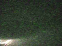
Last night the satellite-internet camera on the bare mountain top on Corsica made its first detections of lightning flashes over northern Italy... not sure yet if there were sprites among them. This is a colour camera image of a lightning channel recorded at 3:22:40 UTC over northern Corsica, pretty close to the camera:
 Météorage detected this flash as well as a double-stroked weak positive discharge:
At the cold front passage on Monday, the eastern half of France will get the storms, but we will likely have a bigger problem with the clouds except Corsica.
Last night the satellite-internet camera on the bare mountain top on Corsica made its first detections of lightning flashes over northern Italy... not sure yet if there were sprites among them. This is a colour camera image of a lightning channel recorded at 3:22:40 UTC over northern Corsica, pretty close to the camera:
 Météorage detected this flash as well as a double-stroked weak positive discharge:
2007/08/03 03:22:39 9401985 9.106700 42.787200 14900(the +CGs were accompanied by a bright flash a bit earlier than the one above, at .970 sec, so the image timestamp works well)
2007/08/03 03:22:39 9585319 9.170800 42.759800 13200
posted by Oscar van der Velde at 21:45
![]()
![]()

0 Comments:
Post a Comment
<< Home