Saturday, July 30, 2005

Thursday Night Sprites!


A very unstable, dynamic weather situation has led to numerous thunderstorms over France last Thursday night (28-29 July). When Pic du Midi finally emerged out of the cloud deck, many sprite events have been recorded between 0128 UT and 0204 UT, some consisted of multiple frames with separate new sprites. Camera operator Agnes Mika, one out of two girls in our team (...), has taken the lead with a topscore of at least 11 sprites so far! She initially thought that she had caught just two sprites, posted the message here and went to bed!

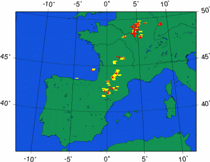
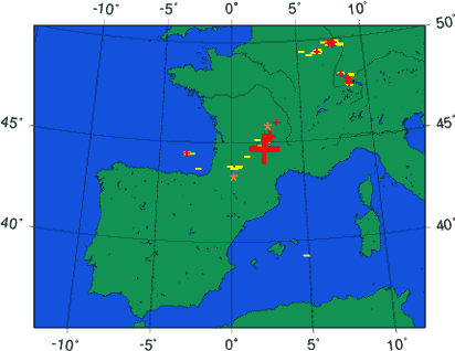
The first sprite was recorded at 0129 UT. A typical multiple-column sprite that was apparently triggered by a 197 kA positive cloud-to-ground flash. This flash has shown up on the lightning map as a big cross. Most sprites happened over this area.


Here is a little gallery of the nicest images for you, in random order. Please respect that you may use these images only in the form as they are presented here, without any modification.


The last sprite image above shows a carrot-type sprite that occurred on 0140 UT. This was the biggest event of the series, many different frames were captured. Note that the wide-view camera has a strange grey-shade problem that needs to be resolved, fortunately the narrow-view camera does yield high quality images. The phenomenal close-up of this carrot sprite, zooming in on the tendrils with beads, is shown below. The first human to witness this unbelievable image was Oscar, who's eyes almost dropped out of his head and his heart skipped a beat!


Since the Danish National Space Center conducted their EuroSprite campaigns in 2000 and 2003, the images above are the most detailed obtained so far!

Friday, July 29, 2005

Thunderstorm Outlook: Fri 29 July

With the last thunderstorms moving out of France, we could perhaps still have an interesting night from Puy de Dôme, if clouds stay away from the camera and if storms remain within range over western Germany. You may try hunting for sprites yourself, if you are far enough from the thunderstorm and have clear sky over the distant anvils, and be very patient, you may get lucky! Sprites will appear as very quick weak red/orange flashes, not connected with the thunderstorm top....

Lightning fest over France...


Lightning at 2245 UT

Here in Toulouse, I can see the second round of storms approaching from the west... flashes at a rate of 1 every second protrude the partly cloudy, hazy sky. This could be a good opportunity to lightning photography soon... Puy de Dôme also has a good storm in view at the moment. Unfortunately, the best storm system, like yesterday, seems to be in a direction straight north from Puy de Dôme, where a building blocks the sight. Let's hope the best for our team!

Thursday, July 28, 2005

Thunderstorm Outlook: Thu 28 July

Was last night enervating with a large Mesoscale Convective System (MCS) moving from central France into western Germany, the following night may even surpass this - the Atlantic cold front pushes into the unstable airmass over France, and strong thunderstorms are expected to form in the 200 km wide zone ahead of it. The initially isolated storms in the afternoon are going to expand and merge into a long squall line or a number of MCS'es over a large portion of France as the night falls, providing a classic setup for a major sprite night. However, a good functioning of the camera systems is crucial.
After this night, cooler air will invade the observation area and high pressure will build on the Atlantic, keeping stormy conditions away for quite some time, except perhaps far over northern Italy.

Wednesday, July 27, 2005

Thunderstorm Outlook: Wed 27 July

A particularly strong thunderstorm event is expected near the thermal low over northern France this afternoon into tonight. Supercells may be able to develop as the vertical windshear and veering of the winds with height support storm rotation. Large hail and even tornadoes will be possible. These cells may merge into a line of storms with a primary risk of gusts, and this MCS during the night offers a good possibility to generate sprites. More isolated convection is likely over central and southern France. See for a thorough discussion http://www.estofex.org.

Monday, July 25, 2005

Night of 24/25 July

Lots of lightning last night but unfortunately the cameras were always under the clouds.

Thunderstorm Outlook Mon 25 - Thu 28 July

This week promises to be very favourable for thunderstorms in southwestern Europe - the flow pattern that we would wish for will at least be present till Thursday and perhaps even Monday next week, yielding a couple good nightly storms. Hopefully the observing conditions cooperate as well... but it seems likely that clouds will sometimes affect observations as moist unstable air also lingers around the Pyrenees.

Tonight the best conditions will come together mostly in southeastern France, near the Alps, with possibly isolated activity stretching from there to the Pyrenees. Tuesday night there may be storm activity developing in southwestern France, Wednesday night the focus for storms seems to be at the warm front over northwestern and central France, and Thursday seems the most classical situation for sprites, as a cold front sweeps through France. Of course, all depends on timing so the outlook may change.

After this week, the ensemble prediction system runs are still very uniform and forecast a dreadful high pressure area occupying the position where there is currently low pressure.

Sunday, July 24, 2005

July 21-23

July 21 and 23 did not have interesting thunderstorms to point the cameras to. We could then do a few more tests and the camera at Puy de Dome was successfully mounted.

July 22 indeed showed some persistent lightning activity over Northern Italy but unfortunately some technical problems caused the camera to observe only for a part of the night. The problem has been solved but we will need to check carefully in the little data we got to see whether we observe any sprites.